 |
 |
 |
|
 |
The Humber Bridge in Toronto crosses one link of the story of how Toronto got its name. Visitors to the 44th Annual Conference & Stage Expo will enjoy exploring streets, rivers, and lakes named from a wide range of languages.
|
|
|
How Toronto Got Its Names
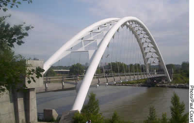
The 2005 USITT Conference & Stage Expo will take place in the city named Toronto, in the province called Ontario, in the country known as Canada : three names from three different aboriginal languages. The name of our country actually derives from a misunderstanding between native villagers and the early French explorer, Jacques Cartier, who began the first European explorations along the St. Lawrence River in 1534. Sailing up the river, Cartier anchored at a village to seek information about this new land. Being the first European contact in this part of the continent, there was no interpreter available. We can only imagine how gamely Cartier tried to make himself understood; what exaggerated mouthings, odd gesticulations, and strange sounds he must have used to convey his question, “What is this place called?” We don’t know how long the villagers watched and listened to this outlandishly dressed, peculiar sounding man before the nature of the question dawned on them. Deciding that this strange fellow was a simpleton who had never seen a civilized habitation before, one of them replied with the single word, Village. Those villagers spoke a now-extinct Iroquoian language, but that one word from their lexicon describing a collection of huts has survived and expanded to encompass the second-largest country on Earth, since their word for village was kanata. The French went on to explore, settle and trade along the length of the St. Lawrence River and the Great Lakes until the English wrested control from them by 1760 during the Seven-Year’s War. In 1791 the colony was divided and the French-speaking area along the St. Lawrence River – generally downstream of the Ottawa River – was named Lower Canada. The section further upstream along the river and the Great Lakes was called Upper Canada. At the time of Confederation in 1867, the name Canada was applied to the entire country, so the old “ Canadas ” had to be renamed. Lower Canada took the name of the capital of the former French colony, which had been built where the St. Lawrence narrowed. It was called Quebec, from the Algonquin word for narrow passage. Upper Canada, meanwhile, took its name from the most easterly of the Great Lakes, since much of the population was clustered along its shoreline. The Huron people had christened it Ontario, which in their language simply means Big Lake. Somewhat redundantly, it is now called Lake Ontario – “ Lake Big Lake.” When it comes to the name of the city, I had shared the general misconception that Toronto was a Huron word meaning meeting place. This popular notion originated with the publication in the nineteenth century of the somewhat fanciful history Toronto of Old by Reverend Scadding. I had even done my own small part to perpetuate that fallacy in an article I wrote in TD&T for the 1999 Annual Conference & Stage Expo. A year ago, however, I met a colleague at Humber College, Dr. John Steckley, who is an expert in native languages and the reigning authority on the Huron language. He has been on a mission to correct a number of popular errors concerning the derivations of place names, so I enlisted his help when preparing this article. According to Dr. Steckley, the true origin of Toronto is historically convoluted and geographically somewhat remote. To find the original site that gave Toronto its name, one actually has to travel well north of the city. 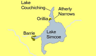 After about an hour’s drive, one reaches the city of Barrie on the northwest arm of Lake Simcoe. At over 280 square miles, this large lake is somewhat dwarfed by the Great Lakes that lie to the north, south, and west. Driving another half hour northeast, passing through the town of Orillia, one reaches the northern tip of the lake where the waters of Lake Couchiching pour into Lake Simcoe. Now known as the Atherly Narrows, these rapids are an ideal place for fishing and have been the site of a fish weir for three or four thousand years. Several native peoples have controlled this area. When the French missionaries arrived, it was Huron land. These missionaries recorded and fell victim to the war in which the Iroquois defeated the Hurons in the seventeenth century. The Mohawks, a member nation of the Iroquois confederacy, then moved north into the area for a time until the Ojibway, in their turn, pushed them back south. While the Mohawks were still in residence, and before the English arrived, a French cartographer adopted the Mohawk name for the fish weir at the north end of the lake. The Mohawks simply referred to the weir as “where there are trees standing in water.” Their word for poles or trees is ront, and the ancient structure was called tkaronto. The cartographer decided to adapt the name for the entire lake, so in a French map published in 1680, the large body of water was labeled Lac Toronteau. It is a linguistic coincidence that the French word for water, eau, is pronounced identically to the Mohawk word for water, o, This lake was part of an important trading route between Lake Ontario and the upper Great Lakes. The major element of this shortcut, which the French dubbed Passage de Toronto, was a river that disgorges into Lake Ontario six miles west of the centre of the city. Today the mouth of that river is spanned by an elegant pedestrian/cycling bridge, which has probably appeared in more feature films, movies of the week, and television episodes than any other structure built in the last two decades. In the early part of the eighteenth century, the French decided that this important water route needed protection from the English. By that time, the river was often referred to as the Toronto River by both English and French, so the new fort was called Fort Toronto. After the English took control, they purchased a large tract of land from the Mississauga Indians, and this transaction was called the Toronto Purchase. The first governor of Upper Canada, John Graves Simcoe, decided to build the colony’s new capital on this site. Simcoe was decidedly an anglophile, and he replaced native names with English ones everywhere he could. The Toronto River was renamed the Humber, and the new settlement was named York. 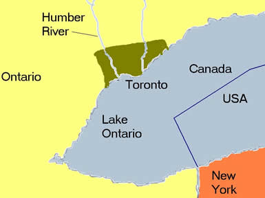 With rapid population growth, the engineers could not keep up with the drainage, and the town was often referred to as Muddy York. The inhabitants soon became impatient with the would-be aristocrats who ran the colony and generally preferred the more euphonious native place names. After a series of petitions, in 1834 the young city reverted to its “real” name of Toronto. Ironically, a few years earlier, Lac Toronteau had been renamed in honour of the first colonial governor, and became Lake Simcoe. The name Toronto had finally completed its 75-mile migration south from a fish weir at the confluence of two lakes. Today, many commuters make the daily drive to Toronto from their homes on the shores of Lake Simcoe. Many buses make journeys in the opposite direction, crossing a bridge over the sacred site of the old weir to deliver their passengers to the nearby casino, which is run by the Ojibway residents. When you come to Toronto for the USITT Conference & Stage Expo, you will find yourself treading the vestiges of the city’s colonial past as soon as you cross the road from the Convention Centre: the area’s streets have names like Wellington, Simcoe, and Richmond; you can ride the streetcars along King and Queen streets; and you may well be staying in the Royal York Hotel. Over the past two generations, however, the old anglo culture has been transformed by a hundred cultures brought by immigrants from all over the world. There are no weirs in Toronto, but tons of fresh fish are flown in daily from both coasts. Walkers, joggers, cyclists, and roller bladers cross the mouth of the Humber River where all evidence of old Fort Toronto has disappeared. Lake Ontario is still a big lake. In the 470 years since Jacques Cartier saw a kanata, this particular village has become the largest city in the country and one of the most diverse in the world. Please join us here next March. |
||