 |
 |
 |
|
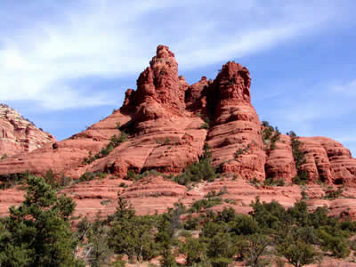 |
Sedona, left, and its red rocks can be seen while visiting Phoenix, Arizona for the 2007 Annual Conference & Stage Expo. Photo/GPCVB
|
|
|
Exploring the Scenic Side
of Phoenix in 2007 At the 2006 Conference & Stage Expo in Louisville, I staffed the Phoenix table at Stage Expo and answered many questions about Phoenix's March weather (the 2007 Conference will be March 14 to17). In general, as verified by www.city-data.com, it should be warm and dry. The average daily high for March is 75 degrees, with 85 percent sunny days and just 0.9 inches of rain for the month. The afternoons typically see a low 25 percent relative humidity. One way to enjoy the great outdoors and great weather of the Phoenix area is to take a day hike. The Phoenix Parks and Recreation Department manages tens of thousand of acres of mountain and desert preserves throughout the city. The largest is South Mountain Park/Preserve. It is the largest municipal park in the United States and covers more than 16,000 acres with 58 miles of trails. The many preserves are free to the public and most are open sunrise to sunset. Hikers have the opportunity to discover breathtaking views of the Valley of the Sun and possibly glimpse some of the native Sonoran Desert plants and animals such as: bursage, brittlebush, creosote bush, palo verde trees, saguaro cactus, Gila monsters, horned lizards, geckos, javelina, and roadrunners. Phoenix's Seven Summits represent the highest hikeable points in seven of the city's mountain parks. Although these hikes can all theoretically be achieved in a single day, hiking any one of them individually also provides a fantastic introduction to the desert region's beauty. The summit trails for each location are listed below, but each of the mountain and desert preserves also contain many more trails. Find more detailed information about the hiking trail systems and fun facts about the mountains at phoenix.gov/PARKS/hikemain.html. Some locations include handicapped-accessible trails. In ascending order: Shadow Mountain, elevation 1,928 feet; one mile round trip; elevation gain 440 feet; rated moderate; facilities: one. Lookout Mountain, elevation 2,054 feet; one mile round trip; elevation gain 475 feet; rated moderate; facilities: water. Lookout Mountain Park on the southeastern side of the mountain has water, restrooms, picnic tables, grills, and a playground. North Mountain, elevation 2,104 feet; 1.6 miles round trip; elevation gain 614 feet; rated moderate; facilities: water, restrooms, picnic areas, grills, and a playground. Shaw Butte, elevation: 2,149 feet; five miles round trip; elevation gain 670 feet; rated moderate; facilities: water, restrooms. Piestewa Peak, elevation 2,608 feet; 2.4 miles round trip; elevation gain 1,190 feet; rated difficult; facilities: water, restrooms, picnic tables, armadas. South Mountain, elevation 2,660 feet; seven miles round trip; elevation gain 1,310 feet; rated difficult; facilities: picnic areas by the trailhead. Camelback Mountain (actually part of the City of Phoenix, not a preserve), elevation 2,704 feet; 2.3 miles round trip; elevation gain 1,300 feet; rated difficult; facilities: toilets and water. It is important to remember that the Phoenix mountain preserves are open, undeveloped desert areas. Use care, since hikers sometimes encounter rocky terrain and other potential hazards native to the Sonoran Desert. |
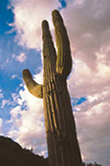 The Saguaro Cactus, above, can grow anywhere from 15 to 50 feet tall, making it the largest type of cactus in the US. Photo/GPCVB  Yes, there are flowers in the desert, including the cactus flower, above. Photo/ Maricopa County Regional Parks (Usery Mountain) | |